
Search an Erie County Street
Start with the address, then keep each source in its proper role. The free County route helps identify a parcel and a recorded transfer. A deed is the document that supports a title reference. A library directory may offer a dated address lead. The voter status tool is not an address-browsing method, and a title party is not automatically a current resident. This sequence makes a street-by-street search more reliable because it separates a parcel fact, a conveyance fact, and a historical listing instead of treating any one of them as proof of a household.
- Enter the house number, direction when applicable, and street name in the County Property and Tax Search. Record the municipality and parcel identifier returned by a matching result.
- Check the parcel on the County map route or GeoHub. Compare the displayed street form and parcel geography before moving to a deed or transfer record.
- Use Recent Property Transfers to locate a dated seller, buyer, instrument label, and reported price where the table displays one. Treat that row as an event lead.
- Take the parcel's legal description or deed reference to the Recorder. Work backward through the grantee, the party receiving property, and the grantor, the party conveying it, rather than assuming a street address is a deed-index field.
- For a dated household lead, inspect the appropriate Erie or Millcreek directory volume at the Heritage Room, including its street or criss-cross section if that volume has one.
Note: Each stop answers a narrower question, so a parcel match, transfer row, deed, and directory entry should be preserved as separate evidence.
Erie County Street Directory Fields
The County's Property and Tax Search says that all visible address fields are optional. Its instructions matter: enter the street name without a type suffix such as Street, St., Road, or Rd. For a west-side address, put the number portion in Street Name and select West as the direction. The separate parcel route accepts exactly 14 numerals with no spaces. When the address form does not find a property, switching to the parcel number or map route is more defensible than guessing a new street spelling.
| County search field | Format | Required | Erie County use |
|---|---|---|---|
| House Number | Numeric input | No | Use the physical street number. |
| Street Direction | Dropdown | No | Select a direction such as West when the address uses one. |
| Street Name | Autocomplete and input | No | Enter the name only, with no street-type suffix. |
| Parcel Number | Numeric text | Yes in parcel mode | Enter 14 digits with no spaces. |
| Oldest and Newest Date | Date text | No | Recent transfers use mm/dd/yyyy dates. |
| Municipality | Dropdown | No | Limits the recent-transfer list by municipality. |
The direct address route also offers Equal To, Begins With, and Contains matching for house number and street name. Those options help test a recorded spelling, but they do not establish that differently named people share an address.
Erie County Street Records by Address
Address-keyed records in Erie County are useful because they reveal different parts of the same property trail. Assessment supplies the situs route, which means the physical location of a parcel. The transfer table supplies a public event layer. The Recorder supplies the underlying recorded instruments, and GIS checks parcel geography. City permit activity can add a dated property-history lead for City of Erie addresses. None of these channels is a general resident register.
| Address record | Custodian | What the record can support | Access boundary |
|---|---|---|---|
| Property address and parcel search | Erie County Assessment | Situs address and 14-digit parcel route | Public query; owner detail is account and payment gated. |
| Recent property transfers | Erie County Assessment | Municipality, address/detail, parties, instrument, price when reported, and date | Public table with date and municipality filters. |
| Deed and map groups | Recorder of Deeds and INFOCON | Recorded party roles, legal descriptions, historic maps, and title references | Counter access plus a fee-based remote subscriber route. |
| Parcel map applications | Erie County GIS | Parcel geography, identifiers, and municipal context | County says public map applications are free. |
| Issued permits | City of Erie eGovPLUS | Address-history activity lead | City-only path; public owner and occupant values are confidential. |
The County's paid Owner tab is a meaningful limit. It requires a registered, logged-in account and a stated $100 unlock payment. A public parcel hit can therefore identify a property without establishing a freely viewable current owner or a mailing address.
City eGovPLUS Street Activity
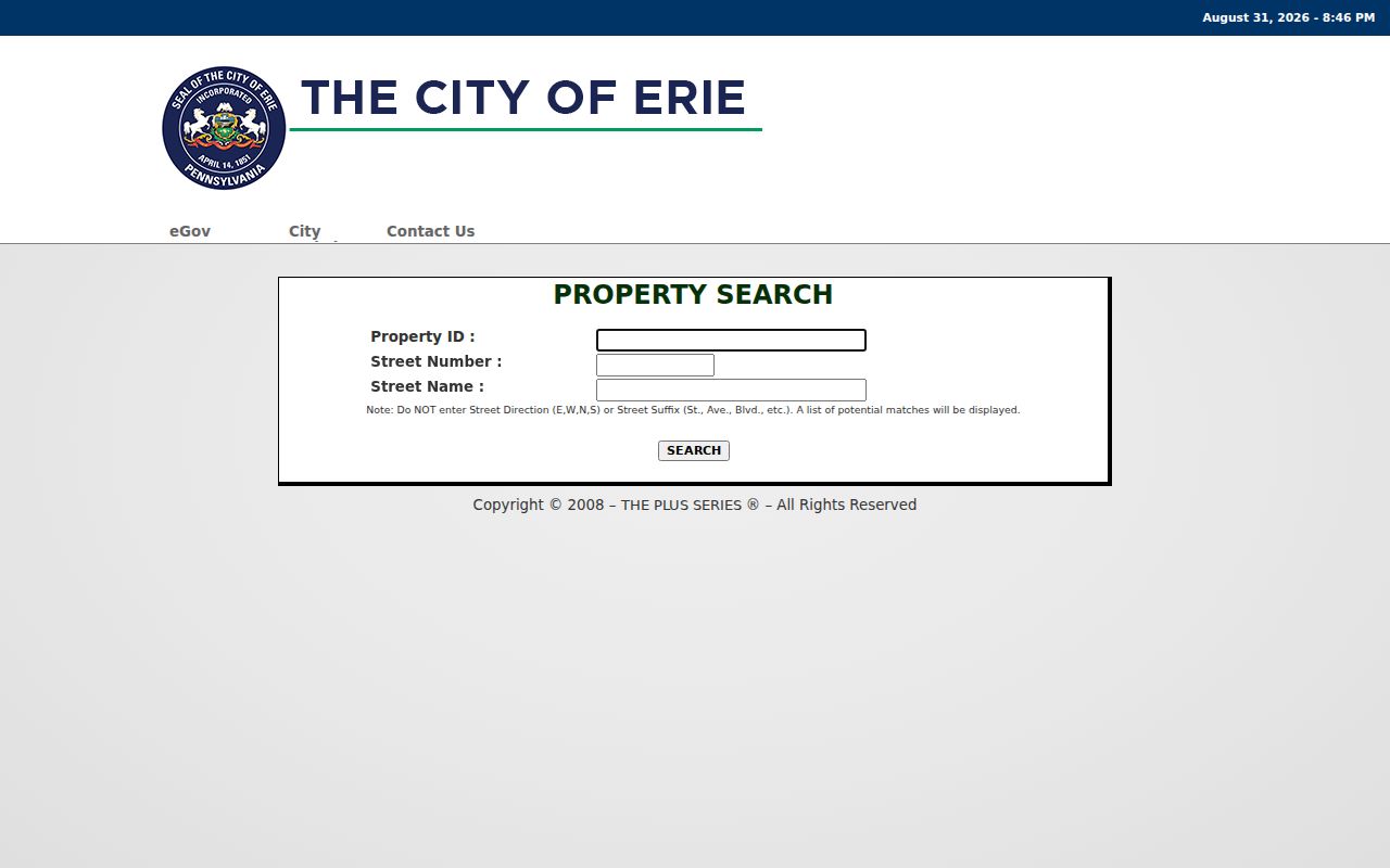
The City of Erie eGovPLUS property search is a City-only supplemental route. It accepts Property ID, Street Number, and Street Name, and it can show property or building attributes and activity tables. Its verified permit columns are Permit Number, Permit Type, Issued, and Status. Zoning Projects and Code Cases have their own activity columns. Use those results as a property-history lead, not as a way to identify a current owner or occupant.
The official City eGovPLUS property search shows the address-entry route used for Erie County street directory research.
For material outside the live display, request it from the proper City office. County Right-to-Know staff cannot supply municipal code or enforcement material held by the City.
Note: A permit applicant, title party, or contact name may have a property role without showing present residence at the address.
Erie County Street Transfer Trail
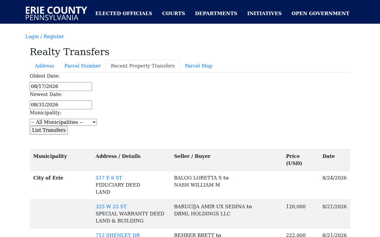
Recent Property Transfers is the quickest public event layer once an address has been found. Its table displays municipality, address or details, seller and buyer, instrument type, price when reported, and date. A blank price does not prove that no consideration occurred. A fiduciary deed, special warranty deed, quitclaim deed, corrective deed, or mobile-home transfer label also does not replace the recorded instrument. The linked address can lead back to a parcel detail route, but fields behind the owner gate must not be assumed visible.
The County's Recent Property Transfers table is the public source for the street-level event information shown here.
To build a deed chain, find the acquisition where a known party appears as grantee. Read the prior grantor on that conveyance, then search the prior grantor as grantee for an earlier acquisition. Keep the legal description, recording date, and book or document reference at every step. This method follows title, not a promise about who lived at the street address.
Erie County Street Deed History
The Recorder of Deeds records and indexes deeds, mortgages, satisfactions, powers of attorney, leases, and other instruments. Its County-linked INFOCON availability listing separates scanned deed books 1 through 1191 marked prior to 1976 from Grantor/Grantee History for 1976 through 1995 and maps for 1976 through 1995. Those labels are helpful historical paths, but they are not a guarantee that every instrument or current cutoff is online.
A free street result may be enough to identify the parcel, yet older deeds can contain a lot, block, subdivision, or another legal description instead of the modern street number. Ask the Recorder about a missing book, year, or document class. The public counter is a separate access channel from the remote subscription service, and the Clerk's record-information page says a staff-performed search costs $20.
- Parcel
- A numbered unit of land used by the County to organize assessment and map records.
- Situs address
- The physical location of the parcel. It can differ from an owner's correspondence address.
- Plat
- A recorded map that lays out lots, blocks, streets, or a subdivision.
- Criss-cross directory
- A directory arrangement that may organize entries by address or street rather than only by name.
Erie County Street Map Check
The Erie County GIS GeoHub is the public starting point for County map applications. In the verified parcel viewer, Find address or place uses County TaxParcel and World Geocoder sources. A parcel click can show FullStreet, TaxPin, municipality, school district, acreage, square footage, legal-description fields, and web or photo links. The viewer also exposes printing, measurement, drawing, coordinates, basemaps, and an attribute table.
Use it to cross-check the geographic parcel after an address search. The research did not verify a native adjacent-owner or owner-radius tool, so do not expect the map to name surrounding households. Select the focal parcel, note its TaxPin and municipal context, then click nearby parcels only as a geography check before returning to Assessment or the Recorder.
Erie County Street Numbers
The City's addressing code provides a useful Erie-specific reference point. In the City grid, north and south numbering begins at Front Street, with 101 as the beginning number, odd numbers on the east side, even numbers on the west side, and 100 numbers per square or block. East and west numbering begins at State Street, with odd numbers south and even numbers north. City Planning and Zoning is required to furnish a correct number on request without charge.
That grid helps explain an address notation, but it is not a countywide conversion table. Honorary street signs do not replace official street names in maps, surveys, or records. A rural or historic deed may use another form entirely, so retain the wording printed in the source before making a search.
Historic Erie County Street Directory Volumes
The Erie County Public Library Heritage Room holds Erie city directories beginning in 1853 and Millcreek or suburban directories beginning with the 1957 edition. That difference is important. An Erie City volume is not proof that it covers a Millcreek address, and a library listing should be checked in the selected volume before assuming it has a reverse or street section. The Heritage Room also has maps, atlases, census microfilm, newspaper microfilm, and an obituary index that can help place a historical address in time.
A street entry is a dated publication fact. Transcribe its spelling, house number, abbreviations, and adjacent entries, then compare nearby annual volumes if available. The 1851 Bevan map and later Sanborn maps help with street and building context, while the directory itself may contain the address or householder lead. For a longer treatment of the collection shelf, use the Erie County city directory.
Note: The research did not establish an exhaustive online list of reverse or criss-cross sections, so each selected volume needs inspection.
Erie County Street Directory Limits
An address chain cannot reliably reveal everyone at a location, a private utility customer, a driver or vehicle address, a protected voter residence, or a person's current whereabouts. The County property portal itself separates public parcel searching from its paid owner-information tab. Pennsylvania's self-registration tool is for an individual's status, not street browsing. The public election-list process under 25 P.S. § 1404 has its own identity and written-purpose requirements, and list information is not for Internet publication.
Protected or substitute addresses are a reason to stop. Motor-vehicle information is restricted under the federal Driver's Privacy Protection Act, and a deed, tax record, directory entry, or court filing can associate a person with a property without showing present residence.
Erie County Street Records Counter
When the online path ends, use the office that holds the record. The Clerk of Records combines the Recorder, court, probate, and marriage functions at the Erie County Courthouse. The Recorder is in Room 121 at 140 W. Sixth Street and lists 814-451-6246. County directory hours for these courthouse offices are Monday through Friday, 8:00 a.m. to 4:30 p.m. A counter visit or clerk-assisted search can resolve a missing book, a legal description, or a copy question that a public screen cannot answer.
For agency records that are not online, Erie County accepts Right-to-Know requests through its submission route and by in-person, mail, email, or fax channels. Courts use a different process under Pennsylvania Judicial Administration Rule 509, and City permit or code material belongs with the City custodian. Give the office the exact address, parcel number, date range, document type, or book reference already found. Specific requests are more likely to reach the right record series.